Beach-on-Map.com The Free Beach Guide HomeCountriesMenu

Barnes Bay beach

Ultimate guide (April 2024)
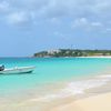
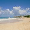
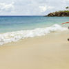
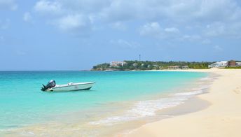
Barnes Bay - is a secluded beach in the north-west of Anguilla island. However, the eastern part of the beach is tightly built with villas. So you'll have to walk a bit in a search of the absolute deserted area. Shore and seabed: sand. [edit]
This beach ranks #4 of the "Best beaches in Anguilla island "
Rating: 8.0 - 314 votes [vote]
Coordinates: 18.175031, -63.150222
See also: Anguilla island

Hotels [edit]

There are a couple of hotels near the beach. They are quite typical for Anguilla.

How to get there [edit]

Fly to Anguilla International Airport. Next hire a taxi.

In most cases it is more convenient to fly to Saint Martin island International Airport, and then take a ferry to Anguilla island.

When to go [edit]

Anguilla can be visited any time of year except for the rainy season from October to November.

Rainfall, mm
Rainfall, mm

Water temperature, C

Temperature, C
Temperature, C

Humidity, %
Humidity, %

Wind speed, meter/sec

Open map

See also other beaches nearby:

 
Anguilla, Cap Juluca beach, balcony view 8.3
1.2 km to the south-east
Location: Caribbean, Anguilla
Rating: 8.3 (131 votes)
Anguilla, Meads Bay beach, view from water 8.5
1.6 km to the north-east
Location: Caribbean, Anguilla
Rating: 8.5 (129 votes)
Anguilla, Rendezvous Bay beach, wet sand 8.6
4.1 km to the east
Location: Caribbean, Anguilla
Rating: 8.6 (600 votes)
Anguilla, Road Bay - Sandy Ground beach 7.8
6.8 km to the east
Location: Caribbean, Anguilla
Rating: 7.8 (323 votes)
Anguilla, Little Bay beach 7.4
10 km to the north-east
Location: Caribbean, Anguilla
Rating: 7.4 (115 votes)
💖
If you liked this page, please share it on: Facebook, Twitter, Instagram
…or any other web-site
 
This will help the project greatly!

 
To the top of this page »
 
© 2024, Beach-on-Map.com · Menu