Barra da Lagoa beach
Ultimate guide (June 2026)
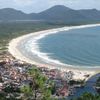
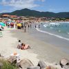
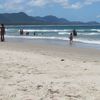
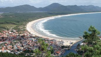
Barra da Lagoa is the longest beach on the island of Santa Catarina, Brazil. The south end of the beach has a lot of restaurants, so there are always many people. But if you walk a little to the north, you will find a miles long secluded coast, sometimes referred as Praia de Moçambique. Shore and seabed: sand. [edit]
Coordinates: -27.571496, -48.426944
See also: Santa Catarina island
Hotels [edit]
Near the beach of Barra da Lagoa, there is a great choice of budget hotels with rooms' rates starting from US$30 per night.
How to get there [edit]
Fly to Florianopolis international airport (FLN). Next hire a taxi or take a bus.
When to go [edit]
The best time to relax on Barra da Lago beach is a warm period from December to March.Rainfall, mm

Water temperature, C
Temperature, C
Humidity, %
Wind speed, meter/sec
See also other beaches nearby:
2.3 km to the south ↓
6.8 km to the south ↓
14 km to the south-west ↙
14 km to the south ↓