Beach-on-Map.com The Free Beach Guide HomeCountriesMenu

Botafogo beach

Ultimate guide (March 2024)
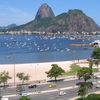
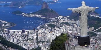
Botafogo is a beach at Guanabara Bay in Rio, - the one that we see from the Christ the Redeemer statue. There are no waves, but the water is very dirty (unlike the open Atlantic beaches). Shore and seabed: sand. [edit]
This beach ranks #8 of the "Best beaches in Rio de Janeiro"
Rating: 7.2 - 504 votes [vote]
Coordinates: -22.944972, -43.181151

Hotels [edit]

In general hotels' level is comparable to those of Copacabana and Ipanema beaches, but prices are a bit cheaper.

How to get there [edit]

Fly to Rio de Janeiro International Airport (GIG). Next hire a taxi. Never catch a taxi on the street! You may just go to the nearest cafe or hotel, and ask to call a taxi for you.

When to go [edit]

The best time for a beach holiday in Rio de Janeiro is a warm period from October to April.

Rainfall, mm
Rainfall, mm

Water temperature, C

Temperature, C
Temperature, C

Humidity, %
Humidity, %

Wind speed, meter/sec

Open map

See also other beaches nearby:

 
Brazil, Rio de Janeiro, Vermelha beach 7.7
2 km to the south-east
Location: South America, Brazil, Rio de Janeiro
Rating: 7.7 (123 votes)
Brazil, Rio, Flamengo beach, skyline 7.5
2.1 km to the north-east
Location: South America, Brazil, Rio de Janeiro
Rating: 7.5 (287 votes)
Brazil, Rio de Janeiro, Copacabana beach 8.5
2.7 km to the south
Location: South America, Brazil, Rio de Janeiro
Rating: 8.5 (402 votes)
Brazil, Rio de Janeiro, Arpoador beach 7.6
5 km to the south
Location: South America, Brazil, Rio de Janeiro
Rating: 7.6 (146 votes)
Brazil, Rio de Janeiro, Ipanema beach 7.9
5.5 km to the south-west
Location: South America, Brazil, Rio de Janeiro
Rating: 7.9 (139 votes)
💖
If you liked this page, please share it on: Facebook, Twitter, Instagram
…or any other web-site
 
This will help the project greatly!

 
To the top of this page »
 
© 2024, Beach-on-Map.com · Menu