Beach-on-Map.com The Free Beach Guide HomeCountriesMenu

Brewers Bay beach

Ultimate guide (April 2024)
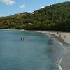
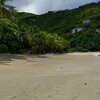
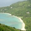
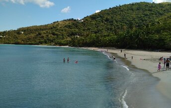
Brewers Bay is a beach in the northwest of Tortola island, British Virgin Islands. The coastline is long enough being shaded by beautiful trees and palms. Entry into the water is also very comfortable. Due to the good location in a deep bay, there are almost never strong waves here. Shore and seabed: sand, stones. [edit]
This beach ranks #4 of the "Best beaches in Tortola island"
Rating: 8.4 - 365 votes [vote]
Coordinates: 18.443098, -64.647265
See also: Tortola island

Hotels [edit]

There are several hotels near Brewers Bay beach. But these are poorly presented in the online booking systems.

How to get there [edit]

Fly to Tortola - Beef Island airport (EIS), and next hire a taxi.

When to go [edit]

Feel free to relax any time of year on the island of Tortola. The hurricane season from June to October is a low season, but it is usually quite good anyway.

Rainfall, mm
Rainfall, mm

Water temperature, C

Temperature, C
Temperature, C

Humidity, %
Humidity, %

Wind speed, meter/sec

Open map

See also other beaches nearby:

 
BVI, Tortola, Cane Garden Bay beach, water edge 8.7
2.3 km to the south-west
Location: Caribbean, BVI, Tortola
Rating: 8.7 (683 votes)
BVI, Tortola, Trunk Bay beach, west 8.3
3.8 km to the east
Location: Caribbean, BVI, Tortola
Rating: 8.3 (762 votes)
BVI, Tortola, Rogues Bay beach, view from hill 7.9
4.4 km to the east
Location: Caribbean, BVI, Tortola
Rating: 7.9 (803 votes)
BVI, Tortola, Nanny Cay beach, aerial view 8.1
5.3 km to the south
Location: Caribbean, BVI, Tortola
Rating: 8.1 (147 votes)
BVI, Tortola, Long Bay Beach, palms 8.2
6.8 km to the south-west
Location: Caribbean, BVI, Tortola
Rating: 8.2 (187 votes)
💖
If you liked this page, please share it on: Facebook, Twitter, Instagram
…or any other web-site
 
This will help the project greatly!

 
To the top of this page »
 
© 2024, Beach-on-Map.com · Menu