Beach-on-Map.com The Free Beach Guide HomeCountriesMenu

Corralejo beach

Ultimate guide (April 2024)
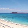
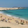
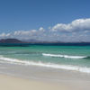
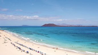
Corralejo - beach on the north of Fuerteventura island. Stretches for many miles along the sand dunes of Corralejo National Park. Shore and seabed: sand. [edit]
Rating: 8.0 - 1122 votes [vote]
Coordinates: 28.68909, -13.831743
See also: Fuerteventura island

Hotels [edit]

You may stay in Corralejo town. Or choose any hotel you like on the island and drive here by car.

How to get there [edit]

Fly to Fuerteventura Airport. Then 30 km to the north by taxi or by bus.

When to go [edit]

In August, as at this time the sea water is the warmest.

Rainfall, mm
Rainfall, mm

Water temperature, C

Temperature, C
Temperature, C

Humidity, %
Humidity, %

Wind speed, meter/sec

Open map

See also other beaches nearby:

 
Spain, Canary Islands, Fuerteventura island, Sotavento beach, aerial view from north 8.4
76 km to the south-west
Location: Europe, Spain, Canary Islands, Fuerteventura
Rating: 8.4 (2431 votes)
Spain, Canary Islands, Gran Canaria island, Playa del Ingles beach, aerial view 7.6
200 km to the south-west
Location: Europe, Spain, Canary Islands, Gran Canaria
Rating: 7.6 (442 votes)
Spain, Canary Islands, Gran Canaria island, Maspalomas beach, dunes 8.3
200 km to the south-west
Location: Europe, Spain, Canary Islands, Gran Canaria
Rating: 8.3 (643 votes)
Spain, Gran Canaria, Anfi del Mar beach 8.1
210 km to the south-west
Location: Europe, Spain, Canary Islands, Gran Canaria
Rating: 8.1 (1033 votes)
Spain, Canary Islands, Tenerife island, Las Teresitas beach, view from the west 8.2
230 km to the west
Location: Europe, Spain, Canary Islands, Tenerife
Rating: 8.2 (490 votes)
💖
If you liked this page, please share it on: Facebook, Twitter, Instagram
…or any other web-site
 
This will help the project greatly!

 
To the top of this page »
 
© 2024, Beach-on-Map.com · Menu