Beach-on-Map.com The Free Beach Guide HomeCountriesMenu

Datai Bay beach

Ultimate guide (April 2024)
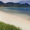
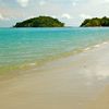
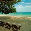
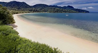
Datai Bay is a secluded beach in the north-west of Langkawi island in Malaysia. The beach itself is not the best. However, it is perfect for those who want to break from the crowds. Shore and seabed: sand. [edit]
This beach ranks #4 of the "Best beaches in Langkawi island"
Rating: 7.4 - 789 votes [vote]
Coordinates: 6.427401, 99.672724
See also: Langkawi island

Hotels [edit]

There are only two hotels near the beach, - both luxury and expensive: The Datai Langkawi and The Andaman Langkawi.

How to get there [edit]

Fly to Langkawi International Airport (LGK). Next hire a taxi.

When to go [edit]

The best time for a beach holiday in the island of Langkawi is a dry season from January to April.

Rainfall, mm
Rainfall, mm

Water temperature, C

Temperature, C
Temperature, C

Humidity, %
Humidity, %

Wind speed, meter/sec

Open map

See also other beaches nearby:

 
Malaysia, Langkawi, Tengkorak beach, view to left 7.3
5.9 km to the east
Location: Southeast Asia, Malaysia, Langkawi
Rating: 7.3 (90 votes)
Malaysia, Langkawi, Kok beach 7.3
Kok / open » /
6.8 km to the south
Location: Southeast Asia, Malaysia, Langkawi
Rating: 7.3 (199 votes)
Malaysia, Langkawi, Burau Bay beach, palms 8.3
7.1 km to the south
Location: Southeast Asia, Malaysia, Langkawi
Rating: 8.3 (788 votes)
Malaysia, Langkawi, Cenang beach, palms 7.9
16 km to the south
Location: Southeast Asia, Malaysia, Langkawi
Rating: 7.9 (149 votes)
Malaysia, Langkawi, Tanjung Rhu beach, sandspit 7.7
17 km to the east
Location: Southeast Asia, Malaysia, Langkawi
Rating: 7.7 (531 votes)
💖
If you liked this page, please share it on: Facebook, Twitter, Instagram
…or any other web-site
 
This will help the project greatly!

 
To the top of this page »
 
© 2024, Beach-on-Map.com · Menu