Beach-on-Map.com The Free Beach Guide HomeCountriesMenu

Fangatave beach

Ultimate guide (March 2024)
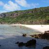
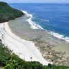
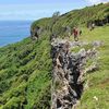
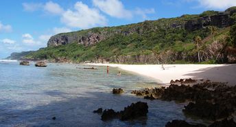
Fangatave is a beach in the north-west of Eua Island in Tonga. The beach itself is nice, looking like The Lost World. Unfortunately, the seabed is almost not suitable for swimming. Most people usually take guided hiking tours around the mountains to get amazing views to the beach from the top. Shore and seabed: sand, stones. [edit]
This beach ranks #15 of the "Best beaches in Tonga"
Rating: 7.5 - 45 votes [vote]
Coordinates: -21.301438, -174.916754
See also: Eua island

Hotels [edit]

The Hideaway is the hotel nearest to the beach of Fangatave. Unfortunately, it is not presented in the international booking systems, like most of other hotels in Eua Island.

How to get there [edit]

Fly to Tonga International Airport (TBU). Next fly to Eua airport (EUA) or take a ferry. Take a taxi, when you are in the island.

When to go [edit]

The best time for trekking around Fangatave beach in Tonga is a dry season from May to October.

Rainfall, mm
Rainfall, mm

Water temperature, C

Temperature, C
Temperature, C

Humidity, %
Humidity, %

Wind speed, meter/sec

Open map

See also other beaches nearby:

 
Tonga, Eua, Tufuvai beach 7.1
8.6 km to the south-west
Location: Oceania, Tonga, Eua
Rating: 7.1 (175 votes)
Tonga, Tongatapu, Oholei beach 7.0
20 km to the west
Location: Oceania, Tonga, Tongatapu
Rating: 7.0 (66 votes)
Tonga, Tongatapu, Pangaimotu island 8.1
32 km to the north-west
Location: Oceania, Tonga, Tongatapu
Rating: 8.1 (177 votes)
Tonga, Tongatapu, Keleti beach 7.2
35 km to the west
Location: Oceania, Tonga, Tongatapu
Rating: 7.2 (224 votes)
Tonga, Tongatapu, Fafa island, beach 8.5
35 km to the north-west
Location: Oceania, Tonga, Tongatapu
Rating: 8.5 (213 votes)
💖
If you liked this page, please share it on: Facebook, Twitter, Instagram
…or any other web-site
 
This will help the project greatly!

 
To the top of this page »
 
© 2024, Beach-on-Map.com · Menu