Beach-on-Map.com The Free Beach Guide HomeCountriesMenu

Malaquite beach

Ultimate guide (April 2024)
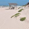
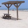
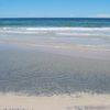
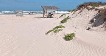
Malaquite is a beach on the Gulf Coast of Texas (Padre island). This is a great wild place without crowds of tourists. However, there is still a small grocery store, as well as visitors' centre of the National Park, where you can get all information related to the beach. Shore and seabed: sand. [edit]
This beach ranks #29 of the "Best beaches in the USA"
Rating: 7.7 - 603 votes [vote]
Coordinates: 27.424291, -97.297803

Hotels [edit]

There are no hotels near Malaquite beach, but a good car camping can be found. The nearest hotels are located just to the north - near the beach of Corpus Christi.

How to get there [edit]

Fly to Houston international airport (IAH). Next hire a taxi or take a bus.

When to go [edit]

The best time for a beach holiday in Malaquite is a warm period from May to October.

Rainfall, mm
Rainfall, mm

Water temperature, C

Temperature, C
Temperature, C

Humidity, %
Humidity, %

Wind speed, meter/sec

Open map

See also other beaches nearby:

 
USA, Texas, Whitecap beach 7.1
21 km to the north-east
Location: North America, USA, Texas
Rating: 7.1 (462 votes)
USA, Texas, Port Aransas beach 7.6
48 km to the north-east
Location: North America, USA, Texas
Rating: 7.6 (595 votes)
USA, Texas, Matagorda Island, beach 7.0
110 km to the north-east
Location: North America, USA, Texas
Rating: 7.0 (231 votes)
USA, Texas, South Padre Island, beach 7.6
140 km to the south
Location: North America, USA, Texas
Rating: 7.6 (775 votes)
USA, Texas, Freeport, Surfside beach 7.2
260 km to the north-east
Location: North America, USA, Texas, Houston
Rating: 7.2 (286 votes)
💖
If you liked this page, please share it on: Facebook, Twitter, Instagram
…or any other web-site
 
This will help the project greatly!

 
To the top of this page »
 
© 2024, Beach-on-Map.com · Menu