Beach-on-Map.com The Free Beach Guide HomeCountriesMenu

Santa Cruz island

Ultimate guide (April 2024)
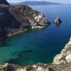
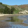
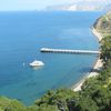
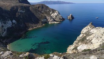
Santa Cruz - is the largest of Channel Islands National Park. It is an ideal eco destination. There are beautiful mountains, beaches and lots of animals. Shore and seabed: stones, sand. [edit]
This beach ranks #13 of the "Best beaches in California"
Rating: 7.4 - 318 votes [vote]
Coordinates: 34.010036, -119.734662
See also: Channel Islands

Hotels [edit]

The island has no hotels, but has a campsite. The nearest hotels are located in Los Angeles.

How to get there [edit]

Fly to Los Angeles International Airport (LAX). There is Island Packers ferry service from the mainland to Santa Cruz island.

When to go [edit]

The best time to visit Santa Cruz island is the warm season from April to October.

Rainfall, mm
Rainfall, mm

Water temperature, C

Temperature, C
Temperature, C

Humidity, %
Humidity, %

Wind speed, meter/sec

Open map

See also other beaches nearby:

 
USA, California, Channel Islands, Santa Rosa island, beach 6.8
34 km to the west
Location: North America, USA, California, Channel Islands
Rating: 6.8 (180 votes)
USA, California, Santa Barbara, East Beach, palms 7.5
45 km to the north
Location: North America, USA, California
Rating: 7.5 (526 votes)
USA, California, Channel Islands, San Miguel island, sea lions 7.3
59 km to the west
Location: North America, USA, California, Channel Islands
Rating: 7.3 (202 votes)
USA, California, El Matador beach, east 7.4
79 km to the east
Location: North America, USA, California, Los Angeles, Malibu
Rating: 7.4 (304 votes)
USA, California, Malibu, Zuma beach 7.3
84 km to the east
Location: North America, USA, California, Los Angeles, Malibu
Rating: 7.3 (277 votes)
💖
If you liked this page, please share it on: Facebook, Twitter, Instagram
…or any other web-site
 
This will help the project greatly!

 
To the top of this page »
 
© 2024, Beach-on-Map.com · Menu