Beach-on-Map.com The Free Beach Guide HomeCountriesMenu

Ship Island

Ultimate guide (April 2024)
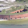
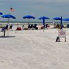
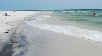
Ship Island is a barrier island in Mississippi, USA. Southern beach faces the open ocean, so the water is clear and even slightly blue. There are no trees on the island, so it is better to rent a parasol ($15) and chair ($5). Near the main pier there is also Fort Massachusetts of 19th century. Shore and seabed: sand. [edit]
This beach ranks #63 of the "Best beaches in the USA"
Rating: 7.3 - 296 votes [vote]
Coordinates: 30.212687, -88.968954

Hotels [edit]

There are no hotels, nor campsites on Ship Island. So feel free to choose any suitable hotel on the mainland, - these are relatively cheap in Mississippi.

How to get there [edit]

Fly to Gulfport–Biloxi airport (GPT). Next get by taxi to Gulfport, and take a daily tour by Ship Island Excursions - except Mondays and Tuesdays.

When to go [edit]

The best time to relax on the beaches of Ship Island is a warm summer half of the year.

Rainfall, mm
Rainfall, mm

Water temperature, C

Temperature, C
Temperature, C

Humidity, %
Humidity, %

Wind speed, meter/sec

Open map

See also other beaches nearby:

 
USA, Mississippi, Biloxi beach 7.2
21 km to the north
Location: North America, USA, Mississippi
Rating: 7.2 (424 votes)
USA, Mississippi, Front Beach 7.0
25 km to the north-east
Location: North America, USA, Mississippi
Rating: 7.0 (69 votes)
USA, Mississippi, Horn Island, beach 7.1
28 km to the east
Location: North America, USA, Mississippi
Rating: 7.1 (422 votes)
USA, Mississippi, Pass Christian beach 7.1
29 km to the west
Location: North America, USA, Mississippi
Rating: 7.1 (1114 votes)
USA, Alabama, Dauphin island, beach 7.4
81 km to the east
Location: North America, USA, Alabama
Rating: 7.4 (120 votes)
💖
If you liked this page, please share it on: Facebook, Twitter, Instagram
…or any other web-site
 
This will help the project greatly!

 
To the top of this page »
 
© 2024, Beach-on-Map.com · Menu