Beach-on-Map.com The Free Beach Guide HomeCountriesMenu

Bahia Honda Key beach

Ultimate guide (April 2024)
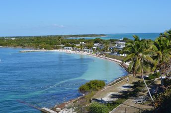
Bahia Honda Key - beach in Florida Keys islands. There is a good view of the old bridge from the northern beach. South beach is more extended with large sandbanks. Shore and seabed: sand. [edit]
Rating: 8.4 - 238 votes [vote]
Coordinates: 24.655103, -81.279643
See also: Florida Keys islands (Key West)

Hotels [edit]

There are only a few hotels on the island, as well as several more hotels on the neighboring Big Pine Key island. In addition, you can sleep in a tent in one of the campsites.

How to get there [edit]

Fly to Key West International Airport (EYW). Then by the car.

When to go [edit]

It is always good here, but the water is warm enough from March to November only.

Rainfall, mm
Rainfall, mm

Water temperature, C

Temperature, C
Temperature, C

Humidity, %
Humidity, %

Wind speed, meter/sec

Open map

See also other beaches nearby:

 
USA, Florida Keys, Marathon, Sombrero beach, aerial view 8.3
20 km to the east
Location: North America, USA, Florida, Florida Keys (Key West)
Rating: 8.3 (971 votes)
USA, Florida Keys, Key West, Smathers beach, volleyball 8.6
51 km to the west
Location: North America, USA, Florida, Florida Keys (Key West)
Rating: 8.6 (1382 votes)
USA, Florida Keys, Key West, Higgs beach, path 6.2
53 km to the west
Location: North America, USA, Florida, Florida Keys (Key West)
Rating: 6.2 (153 votes)
USA, Florida Keys, Key West, Zachary Taylor beach, aerial view 5.5
55 km to the west
Location: North America, USA, Florida, Florida Keys (Key West)
Rating: 5.5 (101 votes)
USA, Florida, Tigertail beach 7.1
150 km to the north
Location: North America, USA, Florida, South Florida, Naples
Rating: 7.1 (116 votes)
💖
If you liked this page, please share it on: Facebook, Twitter, Instagram
…or any other web-site
 
This will help the project greatly!

 
To the top of this page »
 
© 2024, Beach-on-Map.com · Menu