Beach-on-Map.com The Free Beach Guide HomeCountriesMenu

Elbow Cays islands

Ultimate guide (October 2025)
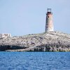
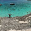
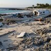
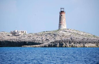
Elbow Cays is a group of small uninhabited islands in the west of Cay Sal Bank atoll in the Bahamas. Islands are mostly rocky - with only one southern island of Cay Sal having sandy beaches. Main tourist attraction is abandoned lighthouse with buildings built in the 19th century. Shore and seabed: rocks, sand. [edit]
This beach ranks #2 of the "Best islands in Cay Sal Bank"
Rating: 6.7 - 1 vote [vote]
Coordinates: 23.992308, -80.339023

Hotels [edit]

There are no hotels in Elbow Cays.

How to get there [edit]

Fly to Nassau international airport (NAS). Next get by speedboat.

When to go [edit]

The best time for a holiday in the Bahamas is a dry season in the winter half of the year. However, the summer is also good. Since sea water is much warmer, and there are no crowds of tourists.

Rainfall, mm
Rainfall, mm

Water temperature, C

Temperature, C
Temperature, C

Humidity, %
Humidity, %

Wind speed, meter/sec

Open map

See also other beaches nearby:

 
Bahamas, Cay Sal Bank, Anguilla Cays island 7.9
100 km to the south-east
Location: Caribbean, Bahamas, Cay Sal Bank
Rating: 7.9 (8 votes)
USA, Florida Keys, Marathon, Sombrero beach, aerial view 8.3
110 km to the north-west
Location: North America, USA, Florida, Florida Keys (Key West)
Rating: 8.3 (1115 votes)
USA, Florida Keys, Bahia Honda Key beach, view from old bridge 8.4
120 km to the north-west
Location: North America, USA, Florida, Florida Keys (Key West)
Rating: 8.4 (279 votes)
Cuba, Varadero, aerial view 8.4
120 km to the south-west
Location: Caribbean, Cuba
Rating: 8.4 (1158 votes)
Cuba, Varadero City beach 8.7
140 km to the south-west
Location: Caribbean, Cuba
Rating: 8.7 (97 votes)
💖
If you liked this page, please share it on: Facebook, Twitter, Instagram
…or any other web-site
 
This will help the project greatly!

 
To the top of this page »
 
© 2025, Beach-on-Map.com · Menu