Beach-on-Map.com The Free Beach Guide HomeCountriesMenu

Chepe's beach

Ultimate guide (May 2024)
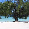
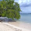
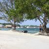
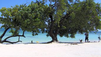
Chepe's is the best beach on the Big Island of Utila group in Honduras. Not to be confused with a private Bandu beach, located nearby. Both beaches are sandy with clear water, trees and occasional palms. Shore and seabed: sand, stones. [edit]
This beach ranks #2 of the "Best beaches in Utila island"
Rating: 7.9 - 263 votes [vote]
Coordinates: 16.095642, -86.903653
See also: Utila island

Hotels [edit]

Most hotels of the Utila island are located near Chepe's beach, and these are inexpensive compared to other Caribbean islands.

How to get there [edit]

Fly to Roatan island international airport (RTB) or fly to La Ceiba airport (LCE). Next take a domestic flight to Utila Airport (UII).

When to go [edit]

The best time for relaxing on the Chepe's beach in Utila island is a dry season from March to August.

Rainfall, mm
Rainfall, mm

Water temperature, C

Temperature, C
Temperature, C

Humidity, %
Humidity, %

Wind speed, meter/sec

Open map

See also other beaches nearby:

 
Honduras, Utila, Water Cay, beach 8.7
8.8 km to the south-west
Location: Central America, Honduras, Utila
Rating: 8.7 (1243 votes)
Honduras, Utila, Little Cay island 7.6
9.3 km to the south-west
Location: Central America, Honduras, Utila
Rating: 7.6 (644 votes)
Honduras, El Porvenir beach 7.9
38 km to the south
Location: Central America, Honduras
Rating: 7.9 (8 votes)
Honduras, Roatan, West Bay, Tabyana Beach 8.5
38 km to the north-east
Location: Central America, Honduras, Roatan
Rating: 8.5 (1094 votes)
Honduras, Playa De Peru beach 8.0
39 km to the south-east
Location: Central America, Honduras
Rating: 8.0 (29 votes)
💖
If you liked this page, please share it on: Facebook, Twitter, Instagram
…or any other web-site
 
This will help the project greatly!

 
To the top of this page »
 
© 2024, Beach-on-Map.com · Menu