Beach-on-Map.com The Free Beach Guide HomeCountriesMenu

Ethel beach

Ultimate guide (April 2024)
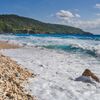
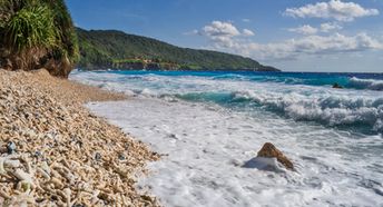
Ethel is a beach on the east of Christmas Island. Most of the coast is not suitable for swimming. However, the east end of the beach has some kind of a natural pool with a sandy bottom. Shore and seabed: pebble, stones, sand. [edit]
This beach ranks #3 of the "Best beaches in Christmas Island"
Rating: 6.2 - 174 votes [vote]
Coordinates: -10.463247, 105.707129
See also: Christmas Island

Hotels [edit]

There are no hotels near the Ethel beach. The nearest hotels are located in the Flying Fish Cove village.

How to get there [edit]

Fly to Christmas Island Airport (XCH). Next hire a taxi.

When to go [edit]

The best time to travel to the beach of Ethel is a dry season from July to October. Unfortunately, that time east wind is dominating, leading to the strong waves.

Rainfall, mm
Rainfall, mm

Water temperature, C

Temperature, C
Temperature, C

Humidity, %
Humidity, %

Wind speed, meter/sec

Open map

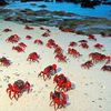
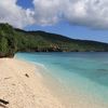
See also other beaches nearby:

 
Christmas Island, Lily beach 6.9
600 m to the south-east
Location: Indian Ocean, Christmas Island
Rating: 6.9 (112 votes)
Christmas Island, Dolly beach 7.3
7.2 km to the south-west
Location: Indian Ocean, Christmas Island
Rating: 7.3 (156 votes)
Cocos isl, Home Island 8.0
980 km to the west
Location: Indian Ocean, Cocos Islands
Rating: 8.0 (115 votes)
Cocos isl, Direction Island, beach, pier 9.2
980 km to the west
Location: Indian Ocean, Cocos Islands
Rating: 9.2 (214 votes)
Cocos isl, West Island, Yacht Club Beach 8.6
990 km to the west
Location: Indian Ocean, Cocos Islands
Rating: 8.6 (194 votes)
💖
If you liked this page, please share it on: Facebook, Twitter, Instagram
…or any other web-site
 
This will help the project greatly!

 
To the top of this page »
 
© 2024, Beach-on-Map.com · Menu