Beach-on-Map.com The Free Beach Guide HomeCountriesMenu

Pohue Bay beach

Ultimate guide (December 2025)
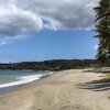
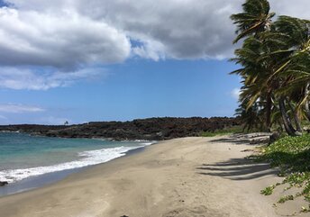
Pohue Bay is a wild beach in the southwest Big Island of Hawaii. There are many picturesque palms. While entry into the water is smooth. However, the best is to swim right near the shore - to avoid dangerous underwater currents. There is also another beach nearby (Kanonone), that is sometimes called Pohue Bay. Shore and seabed: sand, stones. [edit]
Rating: 8.1 - 1 vote [vote]
Coordinates: 19.010484, -155.797146

Hotels [edit]

There are no hotels near Pohue Bay beach.

How to get there [edit]

Fly to Honolulu international airport (HNL). Next fly to Kona international airport (KOA) or fly to Hilo airport (ITO).

When to go [edit]

The best time for a beach holiday in the Big Island of Hawaii is a period from July to October. Since sea water is warm enough that time.

Rainfall, mm
Rainfall, mm

Water temperature, C

Temperature, C
Temperature, C

Humidity, %
Humidity, %

Wind speed, meter/sec

Open map

See also other beaches nearby:

 
Hawaii, Green Sands beach 7.4
18 km to the south-east
Location: Oceania, Hawaii, Hawaii
Rating: 7.4 (7 votes)
Hawaii, Punaluu beach 7.4
34 km to the north-east
Location: Oceania, Hawaii, Hawaii
Rating: 7.4 (7 votes)
Hawaii, Wawaloli beach 4.2
83 km to the north
Location: Oceania, Hawaii, Hawaii
Rating: 4.2 (24 votes)
Hawaii, Mahai'ula beach 8.3
89 km to the north
Location: Oceania, Hawaii, Hawaii
Rating: 8.3 (33 votes)
Hawaii, Makalawena beach 7.9
90 km to the north
Location: Oceania, Hawaii, Hawaii
Rating: 7.9 (33 votes)
💖
If you liked this page, please share it on: Facebook, Twitter, Instagram
…or any other web-site
 
This will help the project greatly!

 
To the top of this page »
 
© 2025, Beach-on-Map.com · Menu