Beach-on-Map.com The Free Beach Guide HomeCountriesMenu

San Sauveur beach

Ultimate guide (April 2024)
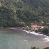
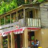
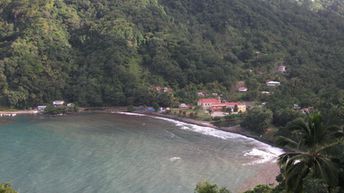
San Sauveur is a small fishing village in the east of Dominica, Caribbean. Thanks to a good location in an enclosed bay, the waves are not so strong in comparison with other beaches of the Atlantic coast of the island. However, the best is just to walk - watching the scenic view of the mountains, and to sit in the bar called Nico's Rum shop. Shore and seabed: stones. [edit]
This beach ranks #18 of the "Best beaches in Dominica"
Rating: 4.6 - 136 votes [vote]
Coordinates: 15.403277, -61.253839
See also: Dominica island

Hotels [edit]

There are no hotels near the beach of San Sauveur. The nearest accomodation options can be found a little to the south - in Rosalie town.

How to get there [edit]

Fly to Douglas–Charles airport (DOM) or fly to Canefield airport (DCF). Next hire a taxi or take a bus.

When to go [edit]

The best time for a holiday on the beach of San Sauveur is a dry period from December to May.

Rainfall, mm
Rainfall, mm

Water temperature, C

Temperature, C
Temperature, C

Humidity, %
Humidity, %

Wind speed, meter/sec

Open map

See also other beaches nearby:

 
Dominica, Wavine Cyrique beach, waterfall 8.6
4.2 km to the south
Location: Caribbean, Dominica
Rating: 8.6 (264 votes)
Dominica, La Plaine beach 4.8
7.1 km to the south
Location: Caribbean, Dominica
Rating: 4.8 (127 votes)
Dominica, Pagua Bay beach, palms 7.5
13 km to the north
Location: Caribbean, Dominica
Rating: 7.5 (61 votes)
Dominica, St. Joseph beach, mushroom rock 7.2
18 km to the west
Location: Caribbean, Dominica
Rating: 7.2 (162 votes)
Dominica, Roseau beach 4.2
19 km to the south-west
Location: Caribbean, Dominica
Rating: 4.2 (251 votes)
💖
If you liked this page, please share it on: Facebook, Twitter, Instagram
…or any other web-site
 
This will help the project greatly!

 
To the top of this page »
 
© 2024, Beach-on-Map.com · Menu