Beach-on-Map.com The Free Beach Guide HomeCountriesMenu

Bathsheba beach

Ultimate guide (April 2024)
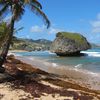
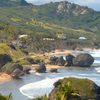
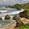
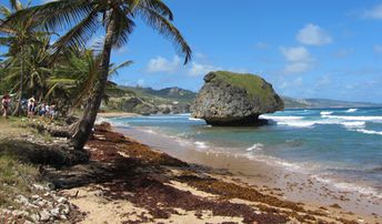
Bathsheba is a beach with stunning views of the wild ocean with huge rocks on the east of Barbados island. This is Atlantic coast, so there is always strong waves. Thus the beach is more suitable for surfing, but not for swimming. Shore and seabed: sand, stones. [edit]
This beach ranks #5 of the "Best beaches in Barbados"
Rating: 8.1 - 793 votes [vote]
Coordinates: 13.212426, -59.51885
See also: Barbados island

Hotels [edit]

Near the beach of Bathsheba there are few good hotels with room's rates starting from as low as US$60 per night.

How to get there [edit]

Fly to Barbados international airport (BGI). Next take the cheap local bus (40-50 minutes from Bridgetown) or hire expensive taxi.

When to go [edit]

The best time for relaxing on Bathsheba beach in Barbados is a dry season from December to May. Summer time is also good, but it's just more rainy.

Rainfall, mm
Rainfall, mm

Water temperature, C

Temperature, C
Temperature, C

Humidity, %
Humidity, %

Wind speed, meter/sec

Open map

See also other beaches nearby:

 
Barbados, Bottom Bay, top view from the north 8.8
13 km to the south-east
Location: Caribbean, Barbados
Rating: 8.8 (529 votes)
Barbados, Gibbs Bay, looking north 7.0
14 km to the west
Location: Caribbean, Barbados
Rating: 7.0 (197 votes)
Barbados, Sandy Lane beach 8.2
14 km to the west
Location: Caribbean, Barbados
Rating: 8.2 (397 votes)
Barbados, Mullins Bay, the shade 6.3
14 km to the west
Location: Caribbean, Barbados
Rating: 6.3 (325 votes)
Barbados, Crane Bay, in the rays of the evening sun 6.4
14 km to the south-east
Location: Caribbean, Barbados
Rating: 6.4 (181 votes)
💖
If you liked this page, please share it on: Facebook, Twitter, Instagram
…or any other web-site
 
This will help the project greatly!

 
To the top of this page »
 
© 2024, Beach-on-Map.com · Menu