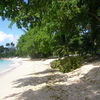
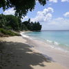
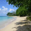
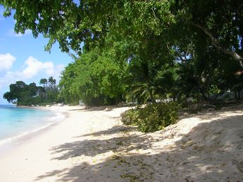
Beach-on-Map.com The Free Beach Guide HomeCountriesMenu

Gibbs Bay beach

Ultimate guide (April 2024)
Gibbs Bay is a small cozy beach next to the south of Mullins Bay. Beach and seabed: sand. [edit]
This beach ranks #8 of the "Best beaches in Barbados"
Rating: 7.0 - 197 votes [vote]
Coordinates: 13.228207, -59.642697
See also: Barbados island

Hotels [edit]

Directly on the beach there are several villas with rooms available for rent. You may also find a hotel at any part of the island and ride here by bus or by car.

How to get there [edit]

Fly to Grantley Adams Airport (BGI). Get to the Mullins Bay beach. Walk to the south along the seashore (3 minutes).

When to go [edit]

From December to May.

Rainfall, mm
Rainfall, mm

Water temperature, C

Temperature, C
Temperature, C

Humidity, %
Humidity, %

Wind speed, meter/sec

Open map

See also other beaches nearby:

 
Barbados, Mullins Bay, the shade 6.3
570 m to the north
Location: Caribbean, Barbados
Rating: 6.3 (325 votes)
Barbados, Heywoods Beach, northern part of the beach 7.4
3.5 km to the north
Location: Caribbean, Barbados
Rating: 7.4 (280 votes)
Barbados, Sandy Lane beach 8.2
6.1 km to the south
Location: Caribbean, Barbados
Rating: 8.2 (397 votes)
Barbados, Brandons Beach 8.1
13 km to the south
Location: Caribbean, Barbados
Rating: 8.1 (685 votes)
Barbados, Bathsheba beach 8.1
14 km to the east
Location: Caribbean, Barbados
Rating: 8.1 (793 votes)
💖
If you liked this page, please share it on: Facebook, Twitter, Instagram
…or any other web-site
 
This will help the project greatly!

 
To the top of this page »
 
© 2024, Beach-on-Map.com · Menu