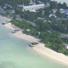
Beach-on-Map.com The Free Beach Guide HomeCountriesMenu

Betio beach

Ultimate guide (April 2024)
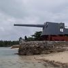
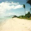
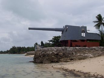
Betio - the best beach in Tarawa island. Actually, the beach itself is rather mediocre. But there are monuments of military history - guns of World War II. As a result trash is sometimes removed from here. Shore and seabed: sand. [edit]
This beach ranks #2 of the "Best beaches in Tarawa island"
Rating: 7.2 - 365 votes [vote]
Coordinates: 1.349255, 172.946437
See also: Tarawa island

Hotels [edit]

There is a good and relatively inexpensive hotel in the Betio village. Other accommodation options are also available, but they often cann't be found in the Web.

How to get there [edit]

Fly to Tarawa International Airport. Next hire a taxi.

When to go [edit]

Any time of year, except for the rainy season (December-January).

Rainfall, mm
Rainfall, mm

Water temperature, C

Temperature, C
Temperature, C

Humidity, %
Humidity, %

Wind speed, meter/sec

Open map

See also other beaches nearby:

 
Kiribati, Tarawa, Bairiki Causeway beach 7.4
3.2 km to the south-east
Location: Oceania, Kiribati, Tarawa
Rating: 7.4 (126 votes)
Tuvalu, Funafuti island, clear water 7.6
1300 km to the south-east
Location: Oceania, Tuvalu
Rating: 7.6 (710 votes)
Vanuatu, Espiritu Santo, Port Olry beach 8.7
1930 km to the south
Location: Oceania, Vanuatu, Central Outer islands, Espiritu Santo
Rating: 8.7 (241 votes)
Vanuatu, Espiritu Santo, Champagne Beach 8.5
1940 km to the south
Location: Oceania, Vanuatu, Central Outer islands, Espiritu Santo, Hog Harbour
Rating: 8.5 (380 votes)
Vanuatu, Espiritu Santo, Lonnoc beach, cruise ship 8.6
1940 km to the south
Location: Oceania, Vanuatu, Central Outer islands, Espiritu Santo, Hog Harbour
Rating: 8.6 (131 votes)
💖
If you liked this page, please share it on: Facebook, Twitter, Instagram
…or any other web-site
 
This will help the project greatly!

 
To the top of this page »
 
© 2024, Beach-on-Map.com · Menu