Beach-on-Map.com The Free Beach Guide HomeCountriesMenu

Da Nang Bay beach

Ultimate guide (June 2025)
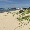
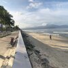
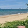
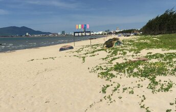
Da Nang Bay is the northern beach of Da Nang, Vietnam. There are no waves. But the swimming is still almost impossible. Since this is an industrial area. Thus sea water is relatively polluted. In addition, coastline is not quite scenic. So walking along the promenade is not very pleasant. Shore and seabed: sand, stones. [edit]
This beach ranks #25 of the "Best beaches in Da Nang"
Rating: 6.2 - 4 votes [vote]
Coordinates: 16.093348, 108.148672

Hotels [edit]

In the hotels of Da Nang Bay, rooms' fares start from as low as US$10 per night. It makes sense to stay here, if you plan to travel by taxi - every day to a new place.

How to get there [edit]

Fly to Da Nang International Airport (DAD). Next hire a taxi.

When to go [edit]

The best time for a beach holiday in Da Nang is a dry season from January to August.

Rainfall, mm
Rainfall, mm

Water temperature, C

Temperature, C
Temperature, C

Humidity, %
Humidity, %

Wind speed, meter/sec

Open map

See also other beaches nearby:

 
Vietnam, Da Nang, Lang Van beach 8.4
7.3 km to the north
Location: Southeast Asia, Vietnam, Central Vietnam, Da Nang
Rating: 8.4 (3 votes)
Vietnam, Da Nang, Tien Sa beach 8.1
8.4 km to the north-east
Location: Southeast Asia, Vietnam, Central Vietnam, Da Nang
Rating: 8.1 (3 votes)
Vietnam, Da Nang, Bai Cat Vang beach 8.4
10 km to the north-east
Location: Southeast Asia, Vietnam, Central Vietnam, Da Nang
Rating: 8.4 (5 votes)
Vietnam, Da Nang, Man Thai beach 8.4
11 km to the east
Location: Southeast Asia, Vietnam, Central Vietnam, Da Nang
Rating: 8.4 (4 votes)
Vietnam, Da Nang, My Khe beach 8.7
12 km to the south-east
Location: Southeast Asia, Vietnam, Central Vietnam, Da Nang
Rating: 8.7 (5 votes)
💖
If you liked this page, please share it on: Facebook, Twitter, Instagram
…or any other web-site
 
This will help the project greatly!

 
To the top of this page »
 
© 2025, Beach-on-Map.com · Menu