Langob beach
Ultimate guide (June 2026)
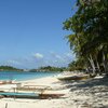
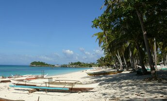
Langob is a long beach in the north of Malapascua island, Philippines. This is the best beach on the island. Strange, but it's not overcrowded. The reason is that it is located far from the main village in the south. In fact, you can walk the distance in 45 minutes, or just take a tuktuk for about US$0.7 per person. The landscape is a postcard - with palms and white sand. Entry into the water is good enough, but broken corals are almost everywhere. Please remember, that Malapascua is rather a diving/snorkeling destination, while the swimming is not the best here. Shore and seabed: sand, stones. [edit]
Coordinates: 11.345334, 124.113639
See also: Malapascua island
Hotels [edit]
D 'Avila's Horizon Malapascua is the only hotel near Langob beach. Room's fares start from as low as US$20 per night. It's quite basic, but value for money if Ok. They provide free sunbeds for their guests. So this option is good enough.
How to get there [edit]
Fly to Cebu international airport (CEB).Then take a taxi to the Maya town located in the north of Cebu island. The cost of the trip is about US$50 per car. You can save if you get to Maya by bus or by shuttle minibus, but the journey will be very hard.
From the main Maya pier to Malapascua island, there are frequent boats (so-called bankas) operating from early morning until 4 pm. It takes 30 minutes per way. If you arrived at the pier after 4 pm, it is better not to pay immediately US$30 for a private boat, but try to find a shared boat for about US$6 per person, - or just spend the night somewhere in the hotel near the pier.
When to go [edit]
You can relax all year round on the island of Malapascua. Probably, the rainy season from June to October is not the best time, but anyway there are many days with good weather.Rainfall, mm

Water temperature, C
Temperature, C
Humidity, %
Wind speed, meter/sec
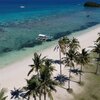
See also other beaches nearby:
790 m to the south-east ↘
1.8 km to the south ↓
2.1 km to the south ↓
200 km to the south ↓