Thresher beach
Ultimate guide (June 2026)
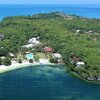
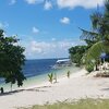
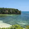
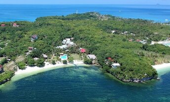
Thresher is a private beach in the northeast of Malapascua island, Philippines. The beach is beautiful and manicured. But the swimming is possible only during the high tide. As for the low tide, the seabed is exposed. So you can only snorkel that time. Shore and seabed: sand, stones. [edit]
Coordinates: 11.339746, 124.118037
See also: Malapascua island
Hotels [edit]
Thresher Cove Resort is a diver oriented property. Probably, this is the best hotel on the island. But still, its quite basic. Unfortunately, it is not presented in international booking systems. But they has a website in the Internet.
How to get there [edit]
Fly to Cebu international airport (CEB).Then take a taxi to the Maya town located in the north of Cebu island. The cost of the trip is about US$50 per car. You can save if you get to Maya by bus or by shuttle minibus, but the journey will be very hard.
From the main Maya pier to Malapascua island, there are frequent boats (so-called bankas) operating from early morning until 4 pm. It takes 30 minutes per way. If you arrived at the pier after 4 pm, it is better not to pay immediately US$30 for a private boat, but try to find a shared boat for about US$6 per person, - or just spend the night somewhere in the hotel near the pier.
When to go [edit]
You can relax all year round on the island of Malapascua. Probably, the rainy season from June to October is not the best time, but anyway there are many days with good weather.Rainfall, mm

Water temperature, C
Temperature, C
Humidity, %
Wind speed, meter/sec
See also other beaches nearby:
790 m to the north-west ↖
1.2 km to the south ↓
1.4 km to the south ↓
200 km to the south ↓