Beach-on-Map.com The Free Beach Guide HomeCountriesMenu

Las Galeras beach

Ultimate guide (April 2024)
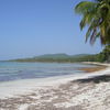
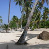
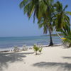
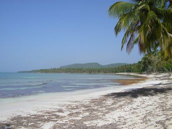
Las Galeras - beach of a small town in Dominican Republic. Also a 15-minute walk from the town there is a better beach - see here. Shore and seabed: sand. [edit]
This beach ranks #34 of the "Best beaches in Dominican Republic"
Rating: 8.3 - 404 votes [vote]
Coordinates: 19.292302, -69.194749
See also: Dominican Republic

Hotels [edit]

The city has several hotels for every taste and budget. Some of them are not presented in booking systems, and you can easily find room on arrival (except for the peak dates).

How to get there [edit]

Fly to Santo Domingo airport or to Puerto Plata airport. Get by bus to Samana town, and next by gua-gua shuttle bus to Las Galeras.

When to go [edit]

Winter is a high season here, because this period there is no rains and hurricanes. But summer featured by warm water and lack of crowds.

Rainfall, mm
Rainfall, mm

Water temperature, C

Temperature, C
Temperature, C

Humidity, %
Humidity, %

Wind speed, meter/sec

Open map

See also other beaches nearby:

 
Dominicana, Playa Aserradero beach, white sand 8.8
880 m to the east
Location: Caribbean, Dominicana
Rating: 8.8 (67 votes)
Dominican Republic, Playa La Playita beach, palms 8.7
1.4 km to the west
Location: Caribbean, Dominicana
Rating: 8.7 (365 votes)
Dominican Republic, Playa Rincon beach, white sand 8.0
5.7 km to the west
Location: Caribbean, Dominicana
Rating: 8.0 (429 votes)
Dominican Republic, Playa Anadel beach, water edge 8.4
16 km to the south-west
Location: Caribbean, Dominicana
Rating: 8.4 (52 votes)
Dominican Republic, Cayo Levantado island, public beach, aerial view 9.0
16 km to the south-west
Location: Caribbean, Dominicana
Rating: 9.0 (205 votes)
💖
If you liked this page, please share it on: Facebook, Twitter, Instagram
…or any other web-site
 
This will help the project greatly!

 
To the top of this page »
 
© 2024, Beach-on-Map.com · Menu