Cayo Levantado island
Ultimate guide (June 2026)
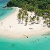
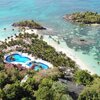
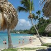
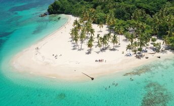
Cayo Levantado is a paradise island in Samana bay, Dominican Republic. It is also known as Bacardi island. Both public beach and private beach are beautiful. However, the latter can only be used by hotel guests. In the winter half of the year, sometimes it is possible to see whales right from the shore. A day tour to the island from Samana town costs from US$40, while combined tour "Cayo Levantado + whales of the Samana Bay" starts from US$70. Typically, more expensive tours include lunch, as well as a more decent boat or even a catamaran. Shore and seabed: sand. [edit]
Coordinates: 19.167963, -69.279188
See also: Dominican Republic
Hotels [edit]
Bahia Principe Luxury Cayo Levantado is a five-star all-inclusive resort with rooms' fares starting from US$300 per night. This is one of the few hotels in Dominicana, where you can feel that you are truly "on the island". You should book directly on their website.
How to get there [edit]
Main airports in Dominican republic: Punta Cana international airport (PUJ), Santo Domingo international airport (SDQ) and Puerto Plata international airport (POP).It is convenient to use a taxi, which is relatively inexpensive. For example, a trip from south to north of the country can cost $100.
To move between the small towns you may use minibuses (shuttle buses). Locals call them gua-gua. One ride costs a few dollars. Bus stations are called parada.
There is also good bus transport system in the country. We recommend Caribe Tours and Metro companies. Buses are brand new, and travel from one end of the country to another will cost about $10.
Though all prices given above are in U.S. dollars, it is better to have local money (peso) when traveling around the country.
When to go [edit]
Feel free to relax in Dominicana any time of year. The sea is warmest in summer, but the heat is the most intense as well. And there is also a hurricane season from June to October. On the other side, the winter weather is more comfortable, but seawater at the northern coast is too cold that time.Rainfall, mm

Water temperature, C
Temperature, C
Humidity, %
Wind speed, meter/sec
See also other beaches nearby:
2.1 km to the north-east ↗