Beach-on-Map.com The Free Beach Guide HomeCountriesMenu

Sol Dorado beach

Ultimate guide (April 2024)
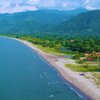
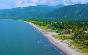
Sol Dorado is the westernmost beach on the Caribbean coast of Honduras. The sand is dark. So the beach looks somewhat depressing. However, it's still good enough. There are occasional palms, no algae in the water, while there is a beautiful view of the mountains in the east. Shore and seabed: sand. [edit]
This beach ranks #29 of the "Best beaches in Honduras"
Rating: 7.5 - 25 votes [vote]
Coordinates: 15.683676, -88.160222

Hotels [edit]

There are several hotels near the beach of Sol Dorado. However, these are not presented in international booking systems.

How to get there [edit]

Fly to San Pedro Sula international airport (SAP). Next take a taxi.

When to go [edit]

The best time for a beach holiday on the Caribbean coast of Honduras is a dry season from March to August.

Rainfall, mm
Rainfall, mm

Water temperature, C

Temperature, C
Temperature, C

Humidity, %
Humidity, %

Wind speed, meter/sec

Open map

See also other beaches nearby:

 
Honduras, Rio Coto beach, fishermen 7.9
12 km to the north-east
Location: Central America, Honduras
Rating: 7.9 (133 votes)
Honduras, Omoa beach, trash 8.1
18 km to the north-east
Location: Central America, Honduras
Rating: 8.1 (109 votes)
Honduras, Playa de Cieneguita beach 8.0
26 km to the north-east
Location: Central America, Honduras
Rating: 8.0 (34 votes)
Honduras, Playa Marejada beach, tiki huts 8.0
31 km to the north-east
Location: Central America, Honduras
Rating: 8.0 (18 votes)
Honduras, Playa Travesia beach, water edge 8.2
33 km to the north-east
Location: Central America, Honduras
Rating: 8.2 (53 votes)
💖
If you liked this page, please share it on: Facebook, Twitter, Instagram
…or any other web-site
 
This will help the project greatly!

 
To the top of this page »
 
© 2024, Beach-on-Map.com · Menu