


Uvero Alto beach
Ultimate guide (June 2026)
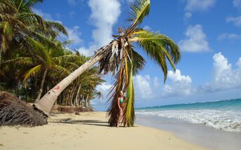
Uvero Alto (Uvero Alto) is a beach to the north of Punta Cana in Dominican Republic. Though all hotels have in their name "Punta Cana", this place has nothing common with Punta Cana. Don't be fooled! There are a lot of picturesque palms ashore, and everything is beautiful. But in the water everything is bad. The main problem is algae. There are many of these, while cleanups are occasional. It depends on the hotel. In fact, there is often even more seaweed in front of the most expensive hotel, than in front of a cheaper one. The second problem is wind with strong waves. This is not so bad, but still unpleasant. The best section of the beach is in the north - near Grand Sirenis Punta Cana Resort. Shore and seabed: sand, stones. [edit]
Coordinates: 18.813147, -68.581049
See also: Dominican Republic
Hotels [edit]
Rooms' fares in the hotels of Uvero Alto range from US$200 to US$600 per night. All hotels are of a very high standard - with great swimming pools and other amenities. However, the real Punta Cana (also known as Bavaro) has even better beachfront resorts.
How to get there [edit]
Main airports in Dominican republic: Punta Cana international airport (PUJ), Santo Domingo international airport (SDQ) and Puerto Plata international airport (POP).It is convenient to use a taxi, which is relatively inexpensive. For example, a trip from south to north of the country can cost $100.
To move between the small towns you may use minibuses (shuttle buses). Locals call them gua-gua. One ride costs a few dollars. Bus stations are called parada.
There is also good bus transport system in the country. We recommend Caribe Tours and Metro companies. Buses are brand new, and travel from one end of the country to another will cost about $10.
Though all prices given above are in U.S. dollars, it is better to have local money (peso) when traveling around the country.
When to go [edit]
Feel free to relax in Dominicana any time of year. The sea is warmest in summer, but the heat is the most intense as well. And there is also a hurricane season from June to October. On the other side, the winter weather is more comfortable, but seawater at the northern coast is too cold that time.Rainfall, mm

Water temperature, C
Temperature, C
Humidity, %
Wind speed, meter/sec
See also other beaches nearby:
11 km to the north-west ↖