
Cap Cana beach
Ultimate guide (June 2026)
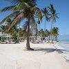
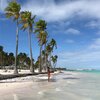
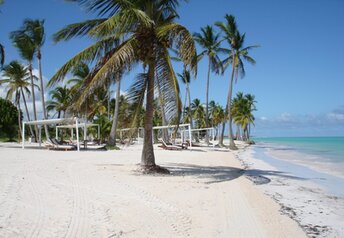
Cap Cana is a beach resort destination located right to the south of Punta Cana airport in Dominican Republic. It is also known as Api Beach (north) and Playa Juanillo (center). In general, it is almost as beautiful as Bavaro. But in many areas the beach looks like artificial one (most likely it is). Anyway, there are many tall palms, while the sand is white, - quite like we expect from Punta Cana. Unfortunately, the water is cloudy, and there is usually a lot of algae. In addition, you have to walk to the depth for a long time. So northern Punta Cana (Bavaro) is still much better. Shore and seabed: sand. [edit]
Coordinates: 18.479709, -68.395064
See also: Dominican Republic
Hotels [edit]
Rooms' fares in Cap Cana hotels range from US$150 to US$5000 per night. So this is upscale and very expensive place. Unfortunately, value for money is not very good in most cases. So you should carefully read the reviews before make a booking.
How to get there [edit]
Main airports in Dominican republic: Punta Cana international airport (PUJ), Santo Domingo international airport (SDQ) and Puerto Plata international airport (POP).It is convenient to use a taxi, which is relatively inexpensive. For example, a trip from south to north of the country can cost $100.
To move between the small towns you may use minibuses (shuttle buses). Locals call them gua-gua. One ride costs a few dollars. Bus stations are called parada.
There is also good bus transport system in the country. We recommend Caribe Tours and Metro companies. Buses are brand new, and travel from one end of the country to another will cost about $10.
Though all prices given above are in U.S. dollars, it is better to have local money (peso) when traveling around the country.
When to go [edit]
Feel free to relax in Dominicana any time of year. The sea is warmest in summer, but the heat is the most intense as well. And there is also a hurricane season from June to October. On the other side, the winter weather is more comfortable, but seawater at the northern coast is too cold that time.Rainfall, mm

Water temperature, C
Temperature, C
Humidity, %
Wind speed, meter/sec