Beach-on-Map.com The Free Beach Guide HomeCountriesMenu

Los Organos beach

Ultimate guide (April 2024)
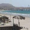
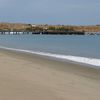
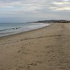
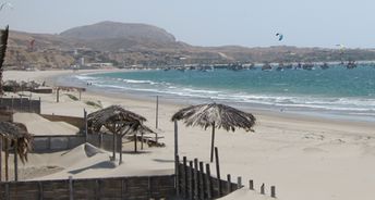
Los Organos - is a beach in the north of Peru suitable both for surfing and swimming. This place is not well known, so there is not a lot of people here. Shore and seabed: sand. [edit]
This beach ranks #5 of the "Best beaches in Mancora region"
Rating: 6.9 - 205 votes [vote]
Coordinates: -4.174566, -81.128118

Hotels [edit]

There is a lot of hotels near the beach. Prices are generally high, but budget accommodation options are also available.

How to get there [edit]

Fly to Lima International Airport (LIM). Next take a bus following to the north in the direction of Mancora town. You may also take a domestic flight to Tumbes town or fly to Piura town, and next get by bus to Los Organos.

When to go [edit]

The best time to relax on the beaches of Peru is a warm period from January to May.

Rainfall, mm
Rainfall, mm

Water temperature, C

Temperature, C
Temperature, C

Humidity, %
Humidity, %

Wind speed, meter/sec

Open map

See also other beaches nearby:

 
Peru, Mancora region, Las Pocitas beach, palms 7.5
8.6 km to the north-east
Location: South America, Peru, Mancora region
Rating: 7.5 (260 votes)
Peru, Mancora region, Mancora beach, tourists 7.3
11 km to the north-east
Location: South America, Peru, Mancora region
Rating: 7.3 (543 votes)
Peru, Mancora region, Cabo Blanco beach, view from water 6.8
14 km to the south-west
Location: South America, Peru, Mancora region
Rating: 6.8 (238 votes)
Peru, Punta Sal beach, hotel aerial view 7.4
30 km to the north-east
Location: South America, Peru, Mancora region
Rating: 7.4 (417 votes)
Peru, Mancora region, Zorritos beach, hammock 7.2
75 km to the north-east
Location: South America, Peru, Mancora region
Rating: 7.2 (180 votes)
💖
If you liked this page, please share it on: Facebook, Twitter, Instagram
…or any other web-site
 
This will help the project greatly!

 
To the top of this page »
 
© 2024, Beach-on-Map.com · Menu