Beach-on-Map.com The Free Beach Guide HomeCountriesMenu

Minicoy atoll

Ultimate guide (April 2024)
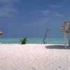
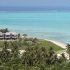
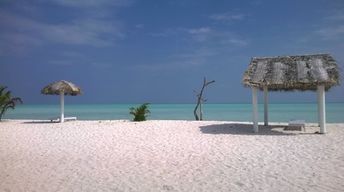
Minicoy is the southern island of Laccadives group in India. This is a classic Maldivian island, and it is located closer to the Maldives than to other Laccadive islands. Shore and seabed: sand. [edit]
This beach ranks #3 of the "Best beaches in Laccadive islands"
Rating: 8.4 - 202 votes [vote]
Coordinates: 8.27509, 73.022385
See also: Laccadive islands

Hotels [edit]

The island has some hotels, but they are not presented in international booking systems.

How to get there [edit]

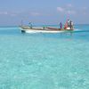
Fly to Agatti Airport (AGX). Next take a helicopter or local boat.

You can also get by ferry from Kochi. In most cases, the ship has a connecting stop at one of the northern islands of Laccadives.

When to go [edit]

The best time to travel to the beaches of Minicoy atoll is a dry season from October to April.

Rainfall, mm
Rainfall, mm

Water temperature, C

Temperature, C
Temperature, C

Humidity, %
Humidity, %

Wind speed, meter/sec

Open map

See also other beaches nearby:

 
Maldives, Raa Atoll, Maakurathu island, beach 8.5
300 km to the south
Location: Indian Ocean, Maldives, Raa Atoll
Rating: 8.5 (259 votes)
India, Laccadives, Agatti, beach, palm over water 8.5
300 km to the north
Location: Indian Ocean, India, Laccadives
Rating: 8.5 (612 votes)
Maldives, Lhaviyani, Kuredu island, beach 8.7
310 km to the south
Location: Indian Ocean, Maldives, Lhaviyani
Rating: 8.7 (489 votes)
India, Laccadives, Bangaram, beach, palms 8.6
310 km to the north
Location: Indian Ocean, India, Laccadives
Rating: 8.6 (439 votes)
Maldives, Lhaviyani, Kanuhura island, beach 8.5
310 km to the south
Location: Indian Ocean, Maldives, Lhaviyani
Rating: 8.5 (152 votes)
💖
If you liked this page, please share it on: Facebook, Twitter, Instagram
…or any other web-site
 
This will help the project greatly!

 
To the top of this page »
 
© 2024, Beach-on-Map.com · Menu